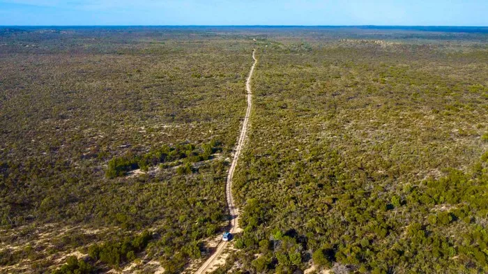
After completing the iconic Border Track along the Victoria-South Australia border, travelers are drawn to a detour leading into one of Victoria’s best-kept secrets—Wyperfeld National Park. This vast and varied landscape is a true outback experience, offering a rugged mix of 4WD tracks, historical landmarks, and remote camping in an untouched environment.
Wyperfeld is Victoria’s third-largest national park, covering a massive 357,000 hectares. The park is carefully divided into three distinct management zones to protect its fragile mallee ecosystems, Aboriginal cultural heritage, and European historical layers. Initially reserved in 1909, it was formally declared a national park in 1921. The Wotjobaluk people, the traditional custodians of this land, are honored throughout the park with interpretive signs marking important cultural sites like middens, artefacts, and burial grounds, all safeguarded under heritage protection.
Each zone within the park offers a unique adventure. To the west lies the Big Desert Wilderness, a 145,000-hectare area of untouched mallee scrub that is only accessible to seasoned hikers. Nestled between the Border Track and the Murrayville Track, it stands as one of Victoria’s most pristine and isolated environments.
Heading north, visitors encounter the State Forest section, where 4WD enthusiasts can explore a network of sandy trails and scattered bush camps. This area features three marked 4WD routes winding through landscapes of red gum, heathland, casuarinas, and steep dunes with soft, beach-like sand.
The Milmed Rock Track is a standout among these routes. Spanning 175 kilometers, it cuts through challenging terrain and takes about seven hours to traverse. Along the way are remote campsites, natural springs, and the distinct Milmed Rock formation.
Separating the Wilderness from the main park, the Nhill-Murrayville Track is an 80-kilometer-long official 4WD route. It is typically a dry, well-graded dirt road, but becomes dangerously slick after rain. Originally constructed in 1860 to move cattle between Nhill and Kow Plains Stations, it was upgraded for motor vehicles in 1936. Today, visitors can still spot historic bores, windmills, and water tanks—remnants of its pastoral heritage.
Camping options along this route include Big Billy, Stockman Camp, and Broken Bucket. Big Billy Camp, one of the oldest sites established in the 1800s, remains a favorite due to its toilets, shelter, interpretive signage, and a short trail leading to a scenic lookout over the vast mallee plains—especially beautiful at sunset.
Wyperfeld’s remote nature is preserved in part because its sandy, infertile soil and low rainfall deterred early European settlers. This has allowed native species to thrive. The park is home to nearly 200 bird species and a variety of reptiles, though snake sightings are rare.
The region’s sweeping sand dunes, shared with the nearby Big and Little Desert areas, formed about 40,000 years ago following the retreat of an inland sea 25 million years prior. These dunes are connected by a network of dry lake beds, linked via Outlet Creek, which eventually leads to Lake Hindmarsh—Victoria’s largest inland freshwater lake. During wet periods, this semi-arid area comes alive with wildflowers, transforming the landscape into a canvas of color.
In the park’s eastern section, shallow lakes bordered by towering red gums, wattles, and casuarinas are interspersed with low heathland. The popular Snowdrift Campground, backed by a massive sand dune, provides a picturesque setting. With toilets, firepits, and open camping spaces, it’s a favorite for both seasoned and casual campers. Climbing the dune is a challenge, but the panoramic views at the top—especially during foggy sunrises or golden sunsets—are unforgettable.
Further south, Wonga Camping Area is accessible to 2WD vehicles and serves as the base for several walking tracks and a 15-kilometer loop drive around Lake Brimin. Along the way, interpretive signs explain the flora, fauna, and landscape features of the mallee ecosystem.
Historically, Pine Plains Station occupied 18,000 hectares in 1855 before being divided into sections. Its southern portion became Wonga Lake Station. Today, a 1934 replica hut offers shelter, and Parks Victoria has built a nearby visitor information centre, showcasing the region’s Indigenous, ecological, and pastoral past. A restored whim, a horse-powered water-drawing device from 1865, is also on display.
From Wonga, the adventurous can take the Fwy Track, which leads north into the park’s more remote areas. High-clearance 4WD vehicles are necessary here, and towing is not recommended due to the deep sand. Travelers should also stay tuned to UHF channel 16 for communication. Along this path, restored rabbiters’ camps offer a glimpse into the 1870s rabbit plague era, when settlers turned to trapping for survival. One such hut remains standing, complete with artefacts and displays capturing that difficult period.
In every direction, Wyperfeld National Park invites exploration—whether through its deep cultural roots, challenging off-road tracks, or breathtaking, timeless landscapes. For anyone seeking a true Victorian outback experience, this destination is a must.
Related Topics
- Game-Changing Portable Shower Delivers Home-Like Pressure for Outdoor Adventures
- Tragedy in Utah: Missing 2-Year-Old Found Dead After Family Camping Trip
- Hidden Gem in the Desert: Camp for Free Near Zion at Utah’s Gooseberry Mesa

